The objective of GADSS is to provide for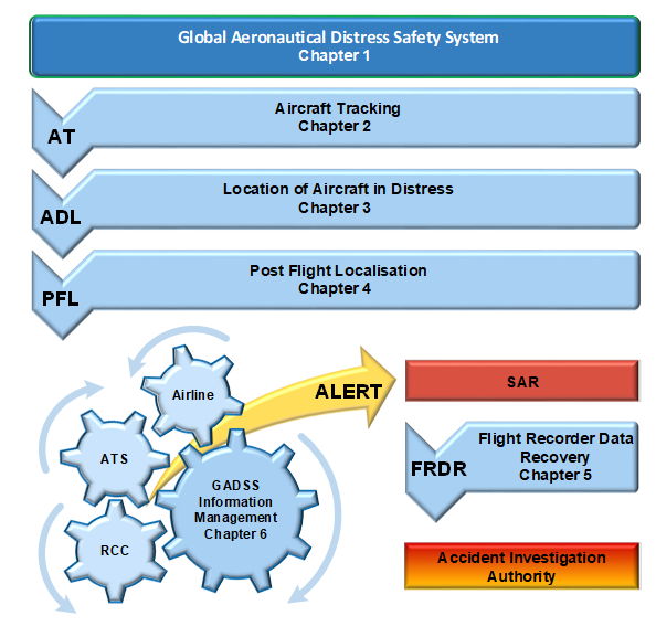
i. detection and subsequent tracking of aircraft in distress;
ii. identification of the accurate location of end of flight;
iii. retrieval of Flight Recorder Data; and
iv. effective SAR operations and Accident Investigation.
To achieve these objectives, 4 main areas were identified, supported by specifically developed information management solutions. These areas are represented in the figure below which is taken from the Manual on Global Aeronautical Distress and Safety System (GADSS) (Doc 10165, expected publication Q3 2024).
Note - References to Chapters relate to the guidance contained in this manual
Aircraft Tracking
Aircraft tracking was the first element of GADSS implemented, since it relied on existing aircraft technology such as the use of ADS-B, and therefore did not require any additional development or certification activities to take place.
The Aircraft Tracking function provides an automated 4 dimensional position (4D – latitude, longitude, altitude and time) at a reporting interval of 15 minutes or less. This is recommended in all areas of operation and required in oceanic areas, for specific categories of aircraft.
The Standards became applicable in Nov 2018 and were intended to provide some degree of certainty that either the Air Navigation Service Provider (ANSP) or the Operator was receiving regular position reports from an aircraft in flight.
The limitation in this requirement, that only mandates reporting over oceanic areas, was specifically intended to address the main areas of operation where no other position reporting facility was available (aircraft over land are typically tracked using ground based receivers or radar installations).
This reporting interval is expected to ultimately reduce the time necessary to resolve the status of an aircraft or when necessary, help to locate an aircraft. This was further reinforced with operator requirements in PANS OPS which established the need for monitoring of the position reports received from aircraft, and the need to take specific action (in the form of a missed position report) when the report was not received as expected.
To facilitate this follow on action, ICAO developed and implemented the OPS CTRL Directory which provides direct operational contact details for both Operators and ANSPs to ensure they can quickly establish contact regarding any possible safety concerns relating to aircraft tracking, regardless of where in the world they are located.
Location of an Aircraft in Distress
While the aircraft tracking function was intended to provide a regular update on the progress of the aircraft, it was recognized that additional tracking requirements would be needed for aircraft that were identified as being in a distress condition.
Note - An aircraft is in a distress condition when it is in a state that if left uncorrected, may result in an accident.
Distress tracking therefore required new equipment to be developed, capable of both detecting the many different possible distress scenarios, and automatically activating a distress signal while the aircraft was still in flight. For this reason, distress tracking needed additional time for development and certification of this new equipment.
To meet the requirements of the Standards introduced in Annex 6, Part I, a system installed on the aircraft must activate autonomously on detection of the condition, transmit position reports at least every minute and be able to be self powered in the event that the aircraft electrical system failed.
The aim of the distress tracking Standard was identified as being able to determine, to a reasonable extent, the location of an accident site within a 6 NM radius. This significantly reduces the search area that would be needed to be covered, dramatically increasing the chances of locating it in a timely manner.
While the newly developed equipment is expected to significantly assist in determining the location of an accident, initial implementation will be limited to requiring new aircraft to be fitted with these systems. Eventually all aircraft of over 27 000 kg produced after 1 January 2024 will be required to be fitted with a distress tracking system, however there is an additional one year period to allow for certification requirements in each State to be completed, meaning that States have until 1 January 2025 to ensure the relevant aircraft are meeting the requirements (see here for more details).
Post flight localization and data recovery
When an accident occurs, there is a phase beginning immediately after the end of flight where the rescue of possible survivors has the immediate and highest priority. Accurate aircraft position information is provided through the Post Flight Localisation function by means of an Emergency Locator Transmitter (ELT) and homing signals to guide SAR services directly to the site. To assist the localisation of the wreckage, the post flight localisation and recovery function specifies a number of requirements for ELTs and additionally for underwater locating devices (ULDs) to assist with reaching the accident site as soon as possible.
Following any accident, understanding the causes remains the key to developing effective strategies to reduce the likelihood of recurrence. To ensure accident investigation authorities obtain timely access to the flight recorder information, new types of large aircraft will have to be equipped with a means to recover the flight recorder data and make it available in a timely manner. The retrieval of flight recorder information contributes to, and often accelerates, determination of the probable cause of the accident.
Different options are available which can be implemented to meet this Standard, which does not specify a technology but rather a requirement to ensure the information is available. Deployable flight data recorders, which detach in the event of an accident and remain floating in water at the accident site are one means to achieve this. Another could be the continuous streaming of flight recorder information from the aircraft, via satellite link, back to the operator or manufacturer. This latter option is still under development but remains an effective means to ensure that following an accident the information needed is immediately available.
GADSS Information Management
Effective information sharing (the right information at the right place at the right time) is essential for emergency handling and SAR. GADSS Information Management is comprised of the following two services:
OPS Control Directory
The OPS Control Directory was established to enable timely coordination between an ATS unit and an operator, initially in response to the aircraft tracking requirements. The OPS Control Directory provides the ATS unit (ACC) and operator OCC operational contact information to facilitate communication. The Ops Control Directory will also include the contact details of RCCs and other users such as other State nominated agencies.
At present this system is maintained by ICAO, however with the development of the LADR (see below) by Eurocontrol it will be combined into the LADR system as both the means to contact relevant stakeholders in a distress scenario, and also the means to authorize users to access the LADR itself.
Location of an Aircraft in Distress Repository (LADR)
Aircraft position information is available to RCCs, ATS units and operators by means of the LADR, which can be accessed through an identified website that will be continuously available. The LADR will serve as the entry point for specific information as detailed in the Manual on the Functional Specifications for the Location of an Aircraft in Distress Repository (LADR) (Doc 10150).
Following successful prototyping of the LADR concept, Eurocontrol agreed to develop and host the operational system on behalf of ICAO. The final agreements and testing are expected to take place in February and March 2024 with the LADR becoming operational in March 2024.
The intent of the LADR is to provide a single centralized location for all stakeholders to gain access to the information relating to the last known position of an aircraft in distress. To this end it is being developed to connect directly to the systems described in the Location of an Aircraft in Distress section. The process by which contributors can apply for connection to the LADR is described Here.
Additional functionality, identified in workshops over the last few years, will also be considered to improve and expand the remit of the LADR. One such option is the inclusion of additional position data from other sources which could be used to further confirm the location of the aircraft.
Go back
